Monday, July 30, 2012

Milepost 243 to 375 - Roanoke to Elmore

~~~~~~~~~~

Merrimac - Milepost 278.3

Sponsored by the Montgomery County Dept. of Parks & Recreation
 

Harry Bundy Picture
Merrimac operator’s shanty was located on the north side of Virginian right of way at milepost 278.3 and just over a hundred yards west of the west portal of Alleghany Tunnel, 5176 feet long. Between these two features, a bridge carried N&W’s Huckleberry Branch over the Virginian, clinking Blacksburg and Christiansburg, Va. A connecting track between the two railroads was near the operator’s shanty.


To reach Merrimac, the traveler may use a paved trail created and maintained by Montgomery County. “The Huckleberry Trail” starts behind the left (south) end of New River Valley Shopping Mall.  Enter the Mall by turning off business 460 onto Radford Road and going to the far left (south) end where a roadway loops behind the mall. Signs for the trail and a parking area are very visible in the back of the mall.  The distance to Merrimac is about ¾ of a mile, 5 minutes on a bike or 15 minutes by walking. The trail crosses the very active NS track beside the old N&W branchline bridge piers. Look to the west for the site of the operator’s shanty and look to the east for the west portal of Alleghany Tunnel.  About one mile beyond Merrimac is the county’s Coal Mining Heritage Park where anthracite coal was once mined. 


The tunnel was 5176 feet long with the crest of grades being at the west portal, 1960 feet above sea level.  The grade for westbound trains approaching the tunnel was 1.5% while .6% was the grade for eastbound trains approaching the tunnel. The tunnel was improved with concrete lining and portals in 1924.


~~~~~~~~~~~~~~~~
 Narrows Power Plant - Milepost 317.4

Sponsored by the Town of Narrows


As the coal traffic on the Virginian began to mushroom by 1920, it became clear a better solution had to be found to get the loaded coal trains out of West Virginia. The grade at Clark’s Gap, west of Princeton, was the steepest and a bottleneck to operations. And it was expensive to operate in its then-current condition. Huge steam locomotives were being used and the trains were slow. At the railroad’s Board of Directors meeting in the spring of 1923, it was decided to commence work to electrify a portion of the railroad. Engineering and design work commenced Nov. 29, 1923 after Virginian’s hiring of the engineering firm of  Gibbs & Hill of New York City, generally identified as pioneers in railroad electrification. One hundred and thirty four miles of the mainline would be electrified. The firm immediately erected a field office at Narrows before construction of the power plant started. To construct the overhead and functioning electric lines for the 133.6 miles of electrified railroad, the railroad directors approved $5,964,973 for catenary in Virginia and $1,977.292 for catenary in West Virginia.
Geo K. Shands Picture, William Clemons Collection

Narrows, Virginia was chosen as the site for the power plant because of a town already there and it being half way between the extreme ends of the electrified territory; Mullens and Roanoke.  The plant’s primary building was 220 feet by 156 feet and roughly 140 feet high. Two brick stacks stood 376 feet tall. There were three turbo generators with a fourth available as needed, each capable of producing 15,000 k.w of electricity.  By means of transformers, the power could be raised to 88,000 volts when it left the plant. The 377 transmission towers, arranged along in more or less straight lines but not necessarily adjacent to the railroad, carried two 88,000 volt circuits. Seven step-down transformer stations were located at Elmore, Clark’s Gap, Princeton, Narrows, Eggleston, Merrimac and Wabun. The 88,000 volts current  from the transmission lines was dropped down to either 11,000 volts or 22,000 volts to be supplied as needed to the trolley lines directly above the tracks for the electric locomotives. 
 
As an illustration of the output of the Narrows Power Plant operation, the 45,000 kilowatts to 60,000 kw produced at the plant in 1925, before any upgrades or modifications, would be sufficient to power the entire City of Princeton, West Virginia in 2010. (sources - 2010 US census and Appalachian Power Company)

 
For its initial electric locomotives, the railroad turned to Alco and Westinghouse; Westinghouse specialized in AC transmission whereas at the time, General Electric preferred DC transmission. While rather simple looking in outward appearance, these three section locomotives could provide tremendous amounts of power, 7,125 hp and 231,000 pounds of tractive effort. The locomotive’s tremendous tractive effort was in part due to its large size, weighing in at over 1.2 million pounds with a length of 152 feet and 3 inches. Initially, Virginian received and operated twelve of these three section locomotives, spending $4,646,292. Within a few years, the last one was divided into three single section locomotives for switching and yard work. During the years of their lifespans, a couple others were separated and then reunited again. Virginian added more electric locomotives of different designs in 1948 and 1956-57.
 
After Virginian’s merger with N&W December 1, 1959, N&W made a token effort to utilize the Virginian’s electric locomotive fleet. The electrics didn’t fit in; they could only be used on a section of the former Virginian line and N&W had cast its lot into the diesel electric locomotive camp earlier. In June 1962, the last train to operate over the old Virginian with electric locomotives made its last run into Roanoke. The engines were a trio of five years old General Electric, 3300 horsepower, class EL-C class locomotives. With no purpose to serve, the Narrows Power Plant was demolished in 1970.

~~~~~~~~~~~~~~~~


Glyn Lyn Bridge - Milepost 323.4

Sponsored by the Town of Glen Lyn


Greg Elam Collection
Vintage newspaper stories date the completion of the last piece of Virginian railroad as being at the west end of New River Bridge at Glen Lyn, Va. on January 23, 1909. The author of one newspaper story reported that the weather was “so cold an Eskimo would freeze.” The bridge was 2155 feet long and about 130 feet above the New River, depending on the water level.
Steve Summers Picture
Local tradition has it that in 1908, as concrete was being poured into the forms for the bridge piers, a worker fell to his death in the wet concrete of the pier second from the west end.  His body was never recovered.

In 1972, after the merger with Norfolk & Western on December 1, 1959, N&W took this area out of service and sold a section of the Virginian right of way to the Virginia Highway Department for a new eastbound lane for route 460.

On January 23, 2009, about a dozen hearty Virginian fans and historians gathered at Princeton and Glen Lyn to observe the centennial of the completion of the railroad. And on that date in 2009, the weather duplicated the conditions of 1909!


 ~~~~~~~~~~~~~~~~~~

Princeton, WV - Milepost 340.2

Sponsored by Princeton Railroad Museum
Delbert WHitlow Picture
Kurt Reisweber Collection


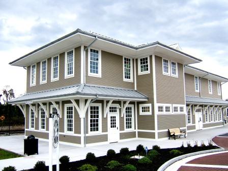
The Princeton, WV station, built in 1912, was one of only two, two-story stations constructed on the Virginian. The other was at Victoria, milepost 119.7, and both housed division offices upstairs. This vintage, hand colored post card shows the side often seen by the public as they approached the station to meet a passenger train. N&W demolished the original building in 1979.
The City of Princeton built a replica station in 2006, while developing the adjacent neighborhood into an historical center. The structure, although not painted in authentic Virginian colors, houses an excellent collection of Virginian artifacts with meeting rooms for social functions. The hours vary so calling is suggested. 304.487.5060. It is located on the site of the original station, 99 Mercer Street. The original freight house is next door.
 
~~~~~~~~~~~~~~~~~~~~~~

 Matoaka, WV- Milepost 356.2


~~~~~~~~~~~~~~~~~~~~~~

Elmore Yard - Milepost 374.7


Approaching Elmore from Princeton on route 10, be alert for several often photographed locations along the way. As crossing a large concrete bridge, be aware of the NS railroad facilities below. The old Virginian mainline from Princeton curves in from the east while the Guyandotte River branch passes under the bridge.  Virginian’s steam engine servicing facilities were in the area to the east of the north end of the bridge.  Turn right onto route 16  to reach Mullens.
 
Tom Marshall Picture
In the recent picture above, the NS locomotive is passing form the westbound mainline onto the Guyandotte River branch to the left. All three legs of a wye are visible in this picture with the westbound mainline being behind the brick railroad office structure. The track with standing camp cars is the leg connecting the eastbound mainline to the Guyandotte River branch. The two miles long Elmore Yard is in the narrow river valley in the top center


~~~~~~~~~~

Milepost 375 - 377 Branches (Guyandot River Branch and Winding Gulf Branch)


Oak Hill Station - Milepost 419.3


The Virginian Oak Hill Station does not resemble other Virginian structures for a very good reason. It was built in 1903 by the White Oak Railway, the railroad facility of owner White Oak Coal Company and the Virginian may not have even been an idea in 1903. Virginian leased the station in 1912 and ultimately purchased it 1922. After the VGN/N&W merger of 1959, N&W continued to use the facility until closure in 1983. It was donated to the City of Oak Hill by Norfolk Southern in 1995.

The station, located at the corner of Virginia and Central avenues in Oak Hill, WV, is owned by the city and used by the White Oak Chapter of the National Railway Historical Society. It is painted in Virginian’s standard color scheme of orange with white trim which was used from the inception of the railroad to 1945.

~~~~~~~~~~~~~

The Deepwater Building, Beckley, WV

Served by means of trackage rights over C&O Ry.

 
Sponsored by John Zuro
 
 
Tom Marshall Picture

Heather Reynolds Picture
 
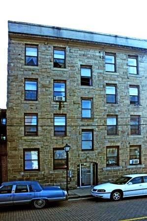
The Deepwater Building, standing in historic downtown Beckley, West Virginia at 128 S. Heber Street, was built circa 1904 by the Deepwater Railroad to be the headquarters of the coal sales office of Loop Creek Colliery of Page and Beards Fork, WV.  H.H. Rogers was a primary owner of both the Deepwater Railway, which became the Virginian Railway in April 1907, and Loop Creek Colliery so the connection is obvious.  In 1910 a devastating  fire consumed nearly all of downtown Beckley, save the stone, four story Deepwater Building.  In 1912 the Virginian Railway sold the structure to a partnership of two Beckley men, a lawyer and a doctor, who rented out the unused professional space to others, including the American Red Cross and the Citizens Bank of Beckley. In 1919 a fire destroyed some of the interior of the structure.  In 1920, the partnership  in turn sold the building to the United Mine Workers Union to serve at headquarters of Distract 29. In the building's second century of life, it offers residential apartments.


~~~~~~~~~~~~~~~~~

Milepost 375 to 435 - Elmore to Deepwater


~~~~~~~~~~~

Mullens, WV - Milepost 376.7

Sponsored by Tom Marshall


Located at the north end of Elmore Yard is Mullens and the site of the famed “Motor Barn” where from 1925 through the N&W merger to the summer of 1962, all electric locomotives were shopped. When diesels started to arrive in the spring of 1954, they were maintained at Mullens Motor Barn as well. In 2011, the structure was demolished. The famed Winding Gulf branch enters the mainline at Gulf Junction, beside the site of the motor barn.
Tom Marshall Picture

Tom Marshall Picture
In 2011-2012, a replica of the Virginian’s Ellett agent-operator’s shanty at Ellett was built in Mullens to serve as a railroader’s museum. It stands in front of the Mullens Opportunity Center (formerly Mullens Grade School) on Guyandot Road.


VGN caboose 307, class C-10, built by St. Louis Car Company in 1948, is preserved and sits near the Rite Aid Pharmacy at 301 Moran Avenue in the north end of the downtown business district.

Standing just east of the intersection of Moran Avenue and Pineville Road in downtown Mullens is this brick VGN structure. It's build date is unclear except that it was built soon after the fire of 1917 in which the VGN Mullens station and two blocks of downtown buildings were destroyed. Built adjacent to the site of the destroyed station building, this brick building served as a baggage storage building. The town had a very brisk passenger service with six trains a day stopping for a while. When Centralized Traffic Control came to this part of the Virginian after World War II, the dispatcher's office was housed  here, controlling trains between Princeton and DB Tower, a distance of 95 miles. 


~~~~~~~~~~~~~~~~~

Slab Fork - Milepost 387.9

Sponsored by Bill Johnson


Opening in 1907, Slab Fork was the first coal mine in the Winding Gulf Coal Field. Initially coal was mined from the Beckley seam but later, mine shafts reached the seam of Pocahontas 3 & 4 coal.A trade publication of 1917 reported the company town of Slab Fork hosting over 200 houses for miners and five more for mine officials. Among its amenities were a movie theater, churches, school which operated eight months of the year.The coal company provided land for light farming and teams for preparing it for cultivation.


Ghislain Gerhard Picture

 Soaring above the town is Virginian’s massive bridge, 613 feet long and eighty feet high.

~~~~~~~~~~~~~

Oak Hill Station - Milepost 419.3


The Virginian Oak Hill Station does not resemble other Virginian structures for a very good reason. It was built in 1903 by the White Oak Railway, the railroad facility of owner White Oak Coal Company and the Virginian may not have even been an idea in 1903. Virginian leased the station in 1912 and ultimately purchased it 1922. After the VGN/N&W merger of 1959, N&W continued to use the facility until closure in 1983. It was donated to the City of Oak Hill by Norfolk Southern in 1995.

The station, located at the corner of Virginia and Central avenues in Oak Hill, WV, is owned by the city and used by the White Oak Chapter of the National Railway Historical Society. It is painted in Virginian’s standard color scheme of orange with white trim which was used from the inception of the railroad to 1945.

~~~~~~~~~~~~~

The Deepwater Building, Beckley, WV

Served by means of trackage rights over C&O Ry.

Sponsored by John Zuro
Tom Marshall Picture

Heather Reynolds Picture
The Deepwater Building, standing in historic downtown Beckley, West Virginia at 128 S. Heber Street, was built circa 1904 by the Deepwater Railroad to be the headquarters of the coal sales office of Loup Creek Colliery of Page and Beards Fork, WV.  H. H. Rogers was a primary owner of both the Deepwater Railway, which became the Virginian Railway in April 1907, and Loup Creek Colliery, so the connection is obvious.  In 1910 a devastating  fire consumed nearly all of downtown Beckley, including thirty businesses, save for the stone, four story Deepwater Building.  Later in that same year the Virginian Railway sold the structure to a partnership of two Beckley men, a lawyer and a doctor, who rented out the unused profession space to others, including the American Red Cross and the Citizens Bank of Beckley. In 1919 a fire destroyed some of the interior of the structure.  In 1920, the partnership in turn sold the building to the United Mine Workers Union to serve at headquarters of Distract 29. In the building's second century of life, it offers residential apartments.
~~~~~~~~~~~~~~~~~

Page - Kincaid - Milepost 426.8

Sponsored by Doug Bess

This 1906 view shows much of Page under construction. At the top, the station is being built and in the upper left, the branch to a coal mine is being graded.  Greg Elam Collection


Page, West Virginia was named for William. N. Page, a civil engineer whose idea it was to buy a logging railroad and extend it south from the Kanawha River to untapped coal deposits. He convinced H.H. Rogers of the validity of his idea and thus, the two men began what would become the Virginian Railway.  C.H. Slayton, Jr, in his book “Virginian Railway Early Years,” states that Page was the operating headquarters for the Deepwater Railroad, 1905-1906. Page was also the headquarters of the Loup Creek Colliery Company which built a company store and a library.  Page was a medium sized marshalling yard located just 8.2 miles from the very end of the railroad at DB tower. There was a wooden three track engine house with a back shop attached on the compass west side. When Princeton received a new 120 foot long turntable in 1919, the old 100 footer was strengthened and moved to Page. In 1939, it was removed and replaced by a wye on which locomotives would be turned.  The old 100 foot turntable saw another life as a highway bridge at Oceana.

In 1967, Doug Bess took this pitcure looking eastbound on the former VGN mainline.


By 1990 all coal mining at Page had ceased and the countryside began to revert back to nature. However, there was still coal to be mined and in 2007 Frazier Mining Company constructed a flood loading facility, using a system of conveyors to bring in coal from two sources; a mountain top strip mine as well as from a deep mine.   By flood loading, entire trains of empty hoppers are loaded while passing under the loader at a slow speed.
Dr. Gerry Albers made this picture of a train being flood laded in October 2011.


~~~~~~~~~~~~~~~~~

Deepwater Area - Milepost 434

Sponsored by Gerry Albers

West Deepwater -August Thieme Picture, AWiley Collection

The VGN Heritage Trail Historical Marker for Deepwater is located at the Church of Living Water, formerly Deepwater United Methodist Church. The church is on the south side of route 61, Deepwater, and on the east side of the VGN’s connecting track to the C&O. The attractive church sits on the side of hill, fronting 61 with the VGN on a side.


Ghislain Gerard Picture

There are four significant locations in this area:

· C&O Deepwater - Down the VGN trackage which passes beside the church, toward the river, is the site of VGN’s connection with the Chesapeake & Ohio railroad and yard. When built, this trackage was the mainline until the line connecting with New York Central on the north side of the Kanawha River was completed in 1931. Today, it is an active NS/CSX connection and yard.
Scott Greathouse Collection

· VACO Jct - Going the opposite direction up the railroad from the church is VACO Junction, created in 1931 when the NYC connection was completed.

· Deepwater Tunnel - Just a very short walk along 61 to the west is Virginian’s bridge over route 61, above which VGN’s shanty shelter for West Deepwater stood. From the site of West Deepwater looking railroad east, the 491.5 foot long Deepwater Tunnel can be seen.
Doug Bess Picture

· DB Tower - Looking railroad west is the Virginian’s bridge over the Kanawha River, 1920.5 feet in length with VGN’s milepost 435 on the far, north side of the river. DB Tower stood within one hundred yards of the end of the Kanawha River bridge and was VGN’s connection with the New York Central railroad. It can be reached from Deepwater by traveling west on route 61 to route 6, turn right to cross the river on the highway bridge over and right onto route 60 east.

This view is from the NYC end of the Kanawah River Bridge. The NYC is behind the photographer and the C&O runs along the far side of the Kanawha River.


Trains leaving the Kanawha River Bridge see this view. DB Tower was just beyond the trees on the left side.


~~~~~~~~~~~~

Charleston, West Virginia


From the very early years of Virginian’s passenger train service in 1909 to January 24, 1952, the western terminus for passenger trains was in Charleston, West Virginia, a distance of 466 miles. From October 10, 1909 to 1931, Virginia’s trains called on Charleston using the Chesapeake & Ohio railroad station.   Situated on McCorkle Ave. SE (route 61) and beside South Side Bridge, the C&O station pictured above was built in 1905. 


Ross Hunter Collection

After 1931, when the VGN Kanawha River bridge was completed, VGN’s passenger service to Charleston was to the New York Central station. The NYC was at the end of Brooks Street and in the 1200 block of Smith Street in downtown Charleston. Baltimore & Ohio Railroad’s passenger trains also called on the NYC station. In the 1908 postcard view above, the view is looking east and Interstate 64 would be built to the left of the railroad.
Ross Hunter Collection

The NYC station whose build date is unknown, had a very interesting history itself. The Ohio Central had built eastward along the north bank of the Kanawha River to reach Charleston in the 1800’s but it went into receivership in 1883 and was sold to the Kanawha & Ohio in 1885. In 1889 the K&O went into receivership and was rechartered as the Kanawha& Michigan. The K&M then extended east of Charleston to Gauley Bridge by buying the Charleston & Gauley Bridge Railroad. The K&M was an independent operation, but was controlled by the Toledo & Ohio, later the Hocking Valley. The C&O acquired a controlling interest in the Hocking Valley , however in 1914 the US District Court forced the C&O to sell the K&M under terms of the Sherman Anti-Trust Act. Control passed back to the Toledo & Ohio Central which was leased by New York Central in 1922. Thanks to Ross Hunter for the NYC station details.